mappatondo

This is not a blog, but just a simple way to keep up with what I do daily...

Wednesday, September 21, 2016

Buffer clip using ESRI JS Geometry Engine

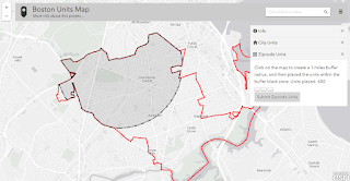
Today I have almost finished coding a mapping application using ArcGIS JS 3.17. You can try it (http://maps.cga.harvard.edu/housing/). Very interesting it was the use of the ESRI geometry engine (https://developers.arcgis.com/javascript/3/jsapi/esri.geometry.geometryengine-amd.html). Below it a screen shot of a buffer (black area) clipped by a polygon (red line).https://gzambotti.github.io/housing/

Posted by Giovanni Zambotti at 11:32 PM No comments:
Newer Posts Older Posts Home
Subscribe to: Posts (Atom)

About Me

My photo
Giovanni Zambotti
Cambridge, MA, United States
View my complete profile

Blog Archive

  • ▼  2016 (1)
    • ▼  September (1)
      • Buffer clip using ESRI JS Geometry Engine
  • ►  2015 (2)
    • ►  August (1)
    • ►  January (1)
  • ►  2014 (5)
    • ►  December (1)
    • ►  October (1)
    • ►  June (1)
    • ►  February (2)
  • ►  2013 (1)
    • ►  January (1)
  • ►  2012 (4)
    • ►  October (1)
    • ►  June (2)
    • ►  March (1)
  • ►  2011 (4)
    • ►  September (2)
    • ►  May (2)
  • ►  2010 (7)
    • ►  November (1)
    • ►  October (3)
    • ►  March (3)
  • ►  2008 (1)
    • ►  April (1)

Labels

Google Maps API ArcGIS Python Maps Presentation Analysis ArcGIS Server CAD EC2 Leaflet Node JS OSM PostGIS Raster Spatial Video
Follow me on Twitter ...on Linkedin ...on Delicious ...on Flicker Follow me on Delicious ...on GitHub ...on Vimeo My CV Write me!
Powered by Blogger.