 https://gzambotti.github.io/housing/
Wednesday, September 21, 2016
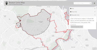
Buffer clip using ESRI JS Geometry Engine
Today I have almost finished coding a mapping application using ArcGIS JS 3.17. You can try it (http://maps.cga.harvard.edu/housing/). Very interesting it was the use of the ESRI geometry engine (https://developers.arcgis.com/javascript/3/jsapi/esri.geometry.geometryengine-amd.html). Below it a screen shot of a buffer (black area) clipped by a polygon (red line).https://gzambotti.github.io/housing/
https://gzambotti.github.io/housing/Friday, August 7, 2015
Visualizing Human Migration through Space and Time
Article about crossroadofmigration app
http://www.isprs-ann-photogramm-remote-sens-spatial-inf-sci.net/II-4-W2/155/2015/isprsannals-II-4-W2-155-2015.pdf
http://www.isprs-ann-photogramm-remote-sens-spatial-inf-sci.net/II-4-W2/155/2015/isprsannals-II-4-W2-155-2015.pdf
Friday, January 23, 2015
From WorldMap Warper to AGOL
WorldMap Warper as well as NYPL Map Warper are great tools to georeference a map online. Tonight I spent a bit of time try to load a rectified map to AGOL. This is the map in AGOL.
Here the trick:
1) Get the WM Warper URL (http://warp.worldmap.harvard.edu/maps/tile/31/z/x/y.png)
2) Change the last z,x,y to {level}{col}{row} [http://warp.worldmap.harvard.edu/maps/tile/31/{level}/{col}/{row}.png]
3) Load it as Tile Service (http://blogs.esri.com/esri/arcgis/2013/03/21/adding-tile-layers-to-your-web-map/)
Wednesday, December 3, 2014
Node JS + Express + PostGIS + Leaflet - Second round
 Ok, I am getting serious now! I was able to replicate what I have been done using cartodb and leaflet (https://github.com/gzambotti/cartodb_leaflet) but with my own PostGIS. The scope is to mimic what ESRI has been done with ArcGIS Server (http://developers.arcgis.com/javascript/samples/query_bypoly/) and its geoprocessing capability.
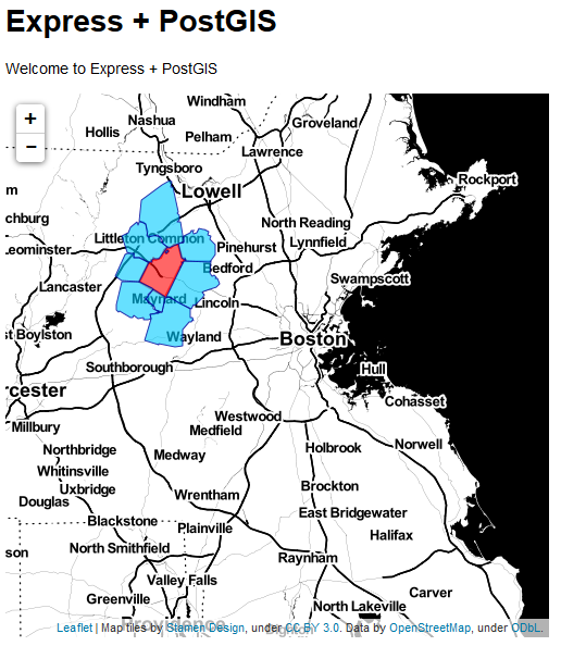
Basically a user can click on map to select a zipcode that intersects the map click and all zipcode that touch selected one; in other worlds getting all the adjacent zips. So, I am not there yet but very close. Happy coding for now...and soon I hope to make it live.
Cheers...
Thursday, October 30, 2014
Node JS + Express + PostGIS + Leaflet
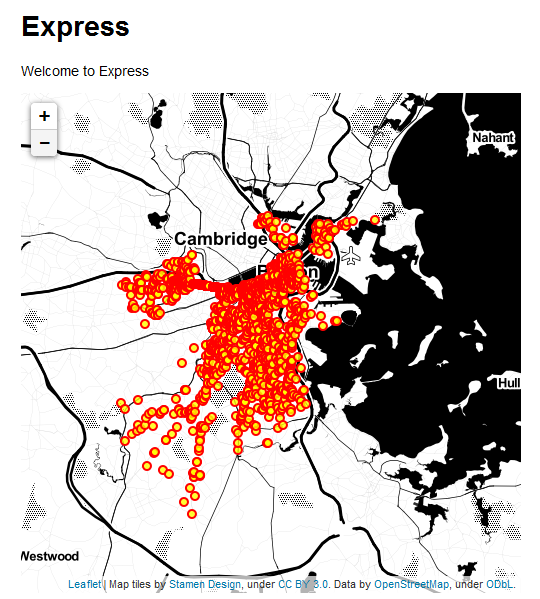 After following an interesting workshop about mapping with Node JS, PostGIS and Leaflet I have got pretty excited, and so I have decided to spend some time with it. I have basically followed this tutorial (http://boomphisto.blogspot.com/2011/07/nodejs-express-leaflet-postgis-awesome.html) and after some issues I created my first map (bikes accident in Boston). Very important put your code before use the routes as suggested here (http://cwbuecheler.com/web/tutorials/2013/node-express-mongo/)
Tuesday, June 10, 2014
Extract an ArcGIS Server Services to a shapefile/feature class
- On the server side you have to use the query capability and retrieve all features in a JSON format. Try it using this link: http://www.geoportal.cl/ArcGIS/rest/services/MinisteriodeViviendayUrbanismo/chile_minvu_ddu_pri_Costero_Ohiggns/MapServer/0/query?text=&geometry=&geometryType=esriGeometryPolygon&inSR=&spatialRel=esriSpatialRelIntersects&relationParam=&objectIds=&where=OBJECTID++%3E+0&time=&returnCountOnly=false&returnIdsOnly=false&returnGeometry=true&maxAllowableOffset=&outSR=&outFields=&f=html As you can see from the form page to get all the features, I set the WHERE field to be OBJECTID > 0, and the Geometry Type to be a Polygon, the Return Field to * (so that I can get all attributes), and the format to be JSON file; then you can click the query button.
- Save out the JSON file you get on your browser, just right click on the browser and choose Save Page As
- Use the tool in ArcMap JSON to Features (http://resources.arcgis.com/en/help/main/10.2/index.html#//001200000057000000)
- Convert the feature class into a shapefile
Tuesday, February 4, 2014
Python and edX
Last semester I have took "Introduction to Computer Science and Programming" at edX (https://www.edx.org/course/mitx/mitx-6-00-1x-introduction-computer-1498). A lot work but I have learned a lot about python.

Subscribe to:
Posts (Atom)